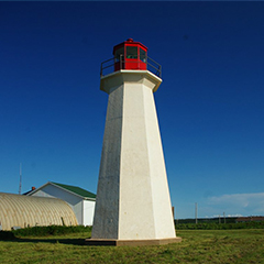
Shipwreck Point Lighthouse

Shipwreck Point Lighthouse / Naufrage Lighthouse - the 13.4 M, 44' tower is one of only two concrete lighthouses on the Island.
It is a hexagonal (six sided) tower located approximately 39.6 M (130') west of the original Shipwreck Point Lighthouse. There is glass all around the lantern.
The tower is painted white. It has a red metal railing surrounding the hexagonal lantern deck. There are no windows. There is a shed dormer over the door.
Driving Directions:

Although this light is on private property, it can be viewed from a public road.
Points East Coastal Drive - From Route 16 on the Points East Coastal Drive at Naufrage, go north on Harbour Road for a short distance, and you will see the lighthouse on your left.
Grounds - tower closed.
GPS Coordinates: 46 28 07.2 N, 62 25 22.6 W
Technical Data
- Status: Active
- LOL number: 1042
- Date Built: 1967
- Electrification and De-staffing Dates: September 27,1967
- Nominal Range: 12 NAUTICAL MILES
- Focal Height: 25.6m, 83' 9"
- Light: Osculating white light
- Flash Pattern: Flash 3 seconds Eclipse 2 seconds
Historic Data
The present Shipwreck Point Lighthouse was built by Schurman’s Limited of Summerside and went into operation on September 27, 1967.
It has always been automated.
Lighthouse Keepers
It never had a keeper.
Current Owners/ Operators:
Government of Canada. A group has filed a petition for ownership under the Parks Canada Heritage Lighthouse Program.
