Brush Wharf Front Range
Brush Point Front Range was located on the south side of the Orwell River. To enter the river, vessels would use the Douse Point Ranges to clear China Point and then pick up the Brush Wharf Ranges to reach the wharf.
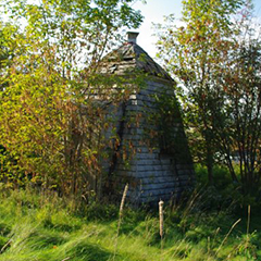
It was a square white tapered tower 15 feet high. Today it is a small unpainted wooden tower in an "extreme state of disrepair". The white paint is gone, turned grey, and there are only a few touches of red surrounding the roof vent and the shed dormer over the window. There is a second smaller window that the navigation light would have shone through. The door way extends vertically like a porch from the sloped side of the tower, topped with a shed dormer.
The interior was finished with matched boards, built to the standards of the late 1800's. It was painted white and still remains so today. Mildew is visible on the walls, and no glass remains in the windows.
The trees are growing around and into the small tower, thus hastening the destruction of this gallant beacon of by-gone days.
Driving Directions:
![]()
Although this light is on private property, it can be viewed from a public road.
Points East Coastal Drive - Traveling on Points East Coastal Drive - Highway #1, 6.4 km (4 miles) east of Vernon Bridge and just south of Orwell, exit onto Orwell Cove Road, and you will find the Bush Wharf Front Range on the right side of the road before Michael Lane.
GPS Coordinates: 46.14 24.2N -62.8 60 58W
Technical Data
- Status: Decommissioned
- Date Built: 1879
- Electrification and De-staffing Dates: Inactive in 1950
- Light: It had a fixed green light
- Tower height: 4.6m, 15'
Historic Data
The Brush Wharf Range Lights were described as follows in The Gulf and River St. Lawrence published in 1908 by the U.S. Navy's Hydrographic Office.
'A square white lighthouse, 15 feet high, on the western side of Brush Wharf, exhibits, at 18 feet above high water, a fixed green light, which should be seen, in clear weather, when in alignment with the following light, 2 miles.
A similar lighthouse, on the left bank of Orwell River 75°, 158 yards from the preceding light, exhibits, at 27 feet above high water, a fixed green light, which should be seen, in clear weather, when in alignment with the preceding light, 2 miles.'
Brush Wharf, also known as Port Selkirk Wharf, was located on the south side of the Orwell River. To enter the river, vessels would use the Douse Point Range Lights to clear China Point and then pick up the Brush Wharf Range Lights to reach the wharf.
The Brush Wharf Range Lights were established in 1899. Daniel W. McPherson served as keeper for several years starting on January 13, 1899 at an annual salary of $60. Prior to the establishment of the Brush Wharf Range Lights, a single red light was used to mark Brush Wharf starting on July 1, 1879.
When the Brush Wharf Range Lights and Douse Point Range Lights commenced operation in 1899, the tower formerly used at Brush Wharf was relocated to serve as the rear light of the Douse Point Range. This tower was square with sloping sides and a height of 6.7 metres (22 feet). John McDonald was the first keeper of the 1879 light on Brush Wharf, also known as the Orwell Light, and he transferred to the Douse Point Range Lights when they were established.
By 2011 the condition of this lighthouse looks beyond repair. Trees are growing through it, and the window has no glass.
It is the lighthouse on the Island that is most urgently in need of maintenance and repair. Action needs to be taken now before it goes completely beyond repair.
The Brush Wharf Front Range Light has been relocated to private property not too far from where it once served. The status of the companion Rear Range light is unknown.
Lighthouse Keepers
1878-1899 - John McDonald
1899-1911 - Daniel W. McPherson
1912-19?? - F. F. Dreeland
"Incidentally, in my original message, we mentioned about trips down to light the lamps in the houses with Kenny MacLeod (who lived on the road now known as the Upper Cove Road), the last lighthouse keeper before they were electrified.
"Before him the keeper was Walter MacLeod also from just up the road (he lived right across from the old schoolhouse in the house now owned by Enman's). He used to come down to light the lights with an old horse and cart. I remember it well, as his horse always was dressed up in an old straw hat with holes cut in the brim for its ears."
Many times we took the same trip with him as well. Both men are now dead."
Historical recollection by David Hunter, of an email sent to Kelly Anne Laughery in 1/30/07.
Current Owners/ Operators:
Located on "private" land not far from its original location.