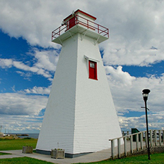
Wood Islands Back Range

The Wood Islands Back Range Light has a square tapered wooden tower, 9.7m (32ft) from base to vane. It has a square lantern with a large window facing seaward and a smaller window on the east side. A narrow wooden deck is surmounted on the tower and is surrounded by a cross-braced railing supported by simple wooden brackets. The red striped vertical day mark on its seaward side was removed when this range light was decommissioned in 2007.
Driving Directions:

Points East Coastal Drive - Take the ferry from Caribou, Nova Scotia or Highway 1 from Charlottetown on Prince Edward Island to reach Wood Islands. Near the ferry landing, take Lighthouse Road east to Wood Islands Lighthouse site.
GPS Coordinates: 45 56 59.5 N 62 44 46.1 W
Technical Data
- Status: Decommissioned
- FHBRO Number: 90-115
- LOL number: 974
- Date Built: 1902
- Electrification and De-staffing Dates: Decommissioned in 2007.
- Nominal Range: 6 NAUTICAL MILES
- Focal Height: was 11.4m, 37'4 "
- Light: was fixed yellow light
- Tower height: 9.7m, 32'
Historic Data
In 1902, the Wood Islands Back Range Light was constructed overlooking the Northumberland Strait that leads into Wood Islands Harbour. It was useful to the fishing fleet and Northumberland Ferries Limited after 1940.
It is believed that the range light was moved about 1940 when construction of the ferry terminal at Wood Islands began.
This Back Range Light was decommissioned in 2007.
In 2013 this range light was moved to the lighthouse site.
Lighthouse Keepers
1902-19?? - James Young - This is the only name available.
Current Owners/ Operators:
Wood Islands and Area Development Corporation.
